Environmental Studies of the World Trade Center area after the September 11, 2001 attack.Version 1.1 Published November 27, 2001 Roger N. Clark1, Robert O. Green2, Gregg A. Swayze1, Greg Meeker1, Steve Sutley1, Todd M. Hoefen1, K. Eric Livo1, Geoff Plumlee1, Betina Pavri2, Chuck Sarture2, Steve Wilson1, Phil Hageman1, Paul Lamothe1, J. Sam Vance3, Joe Boardman4 Isabelle Brownfield1, Carol Gent1, Laurie C. Morath1, Joseph Taggart1, Peter M. Theodorakos1, and Monique Adams1 ___________
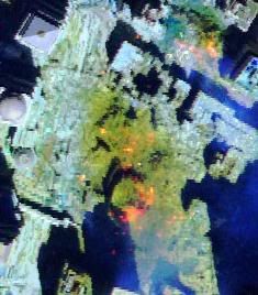
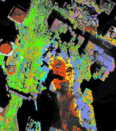
Executive SummaryThis web site describes the results of an interdisciplinary environmental characterization of the World Trade Center (WTC) area after September 11, 2001. Information presented in this site was first made available to the World Trade Center emergency response teams on September 18, 2001 (Thermal hot spot information), and September 27, 2001 (maps and compositional results). The Airborne Visible / Infrared Imaging Spectrometer (AVIRIS), a hyperspectral remote sensing instrument, was flown by JPL/NASA over the World Trade Center (WTC) area on September 16, 18, 22, and 23, 2001 ( Link to the AVIRIS JPL data facility). A 2-person USGS crew collected samples of dusts and airfall debris from more than 35 localities within a 1-km radius of the World trade Center site on the evenings of September 17 and 18, 2001. Two samples were collected of indoor locations that were presumably not affected by rainfall (there was a rainstorm on September 14). Two samples of material coating a steel beam in the WTC debris were also collected. The USGS ground crew also carried out on-the-ground reflectance spectroscopy measurements during daylight hours to field calibrate AVIRIS remote sensing data. Radiance calibration and rectification of the AVIRIS data were done at JPL/NASA. Surface reflectance calibration, spectral mapping, and interpretation were done at the USGS Imaging Spectroscopy Lab in Denver. The dust/debris and beam-insulation samples were analyzed for a variety of mineralogical and chemical parameters using Reflectance Spectroscopy (RS), Scanning Electron Microscopy (SEM), X-Ray Diffraction (XRD), chemical analysis, and chemical leach test techniques in U.S. Geological Survey laboratories in Denver, Colorado.
Next section: continue to the Introduction, below. IntroductionThe information in this report describes the results of an interdisciplinary environmental characterization of the World Trade Center (WTC) area following requests from other Federal agencies after the attack on September 11, 2001. The scientific investigation included two main aspects: 1) imaging spectroscopy mapping of materials to cover a large area around the WTC and 2) laboratory analysis of samples collected in the WTC area. Spectroscopy is a tool that detects chemical bonds in molecules (solid, liquid or gas) through absorption (or emission) features in the spectrum of the material. Imaging spectroscopy obtains a spectrum for every spatial pixel in an image format. Data from the Airborne Visible/Infrared Imaging Spectrometer (AVIRIS) were collected over the WTC area by NASA/JPL for this study. The results of the imaging spectroscopy mapping are shown below. The analytical techniques applied to this study include X-Ray Diffraction (XRD), Scanning Electron Microscopy (SEM) with elemental analysis by Energy Dispersive Spectroscopy (EDS), laboratory Reflectance Spectroscopy (RS), leachable metals, and X-Ray Fluorescence Spectroscopy (XRF). For definitions of asbestos, CLICK HERE (use the back button on your browser to return here). Next section: click on the link to Results of Imaging Spectroscopy Mapping, below
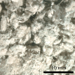
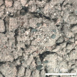
Sample Collection in the WTC Area Ground sampling consisted of collecting debris from 35 locations in the WTC area, including 33 dust, 2 concrete, and 2 steel beam insulation samples. Optical photographs of a typical dust sample on the left (sample WTC01-27) and what appeared to be an insulation coating from a steel beam on the right (WTC01-8). The coating contains as much as 20% chrysotile asbestos. Scale bar is 10 millimeters. Laboratory Studies of SamplesOverviewThe objective of the laboratory analysis was to characterize the samples for potential environmental impacts and to provide feedback to imaging spectral analysis and field confirmation of the imaging spectroscopy results. In certain cases the laboratory studies provide better detection levels than airborne imaging spectroscopy, thus providing complimentary information that allowing a more robust characterization of the entire site.
Integration of Results and ConclusionsReferencesAcknowledgements
|
|||||||||||||||||||
| AccessibilityFOIAPrivacyPolicies and Notices | |
 |
|
|
In accordance with Title 17 U.S.C. Section 107, the articles posted on this webpage are distributed for their included information without profit for research and/or educational purposes only. This webpage has no affiliation whatsoever with the original sources of the articles nor are we sponsored or endorsed by any of the original sources.
© 2006-2007 Judy Wood. All rights reserved. |
| Top | homepage |
|
|
|
|


