I'll add new pictures from the bottom up and leave the maps in place, here at the top.

JUMP to where the most recent pictures are.

https://janedoe0911.tripod.com/morepics_C.html
https://janedoe0911.tripod.com/morepics_B.html
https://janedoe0911.tripod.com/morepics_A.html
http://www.911scholars.org/word/GZ.html
https://janedoe0911.tripod.com/OKC.html
https://janedoe0911.tripod.com/list.html
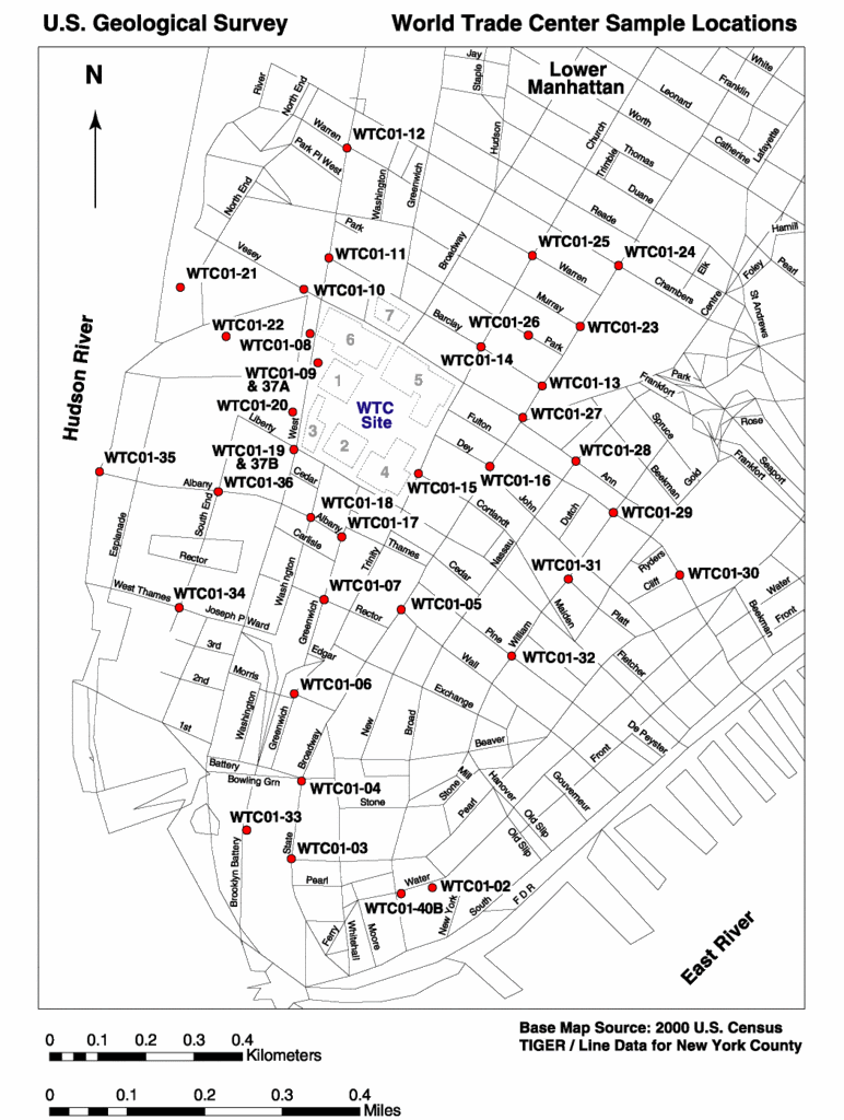
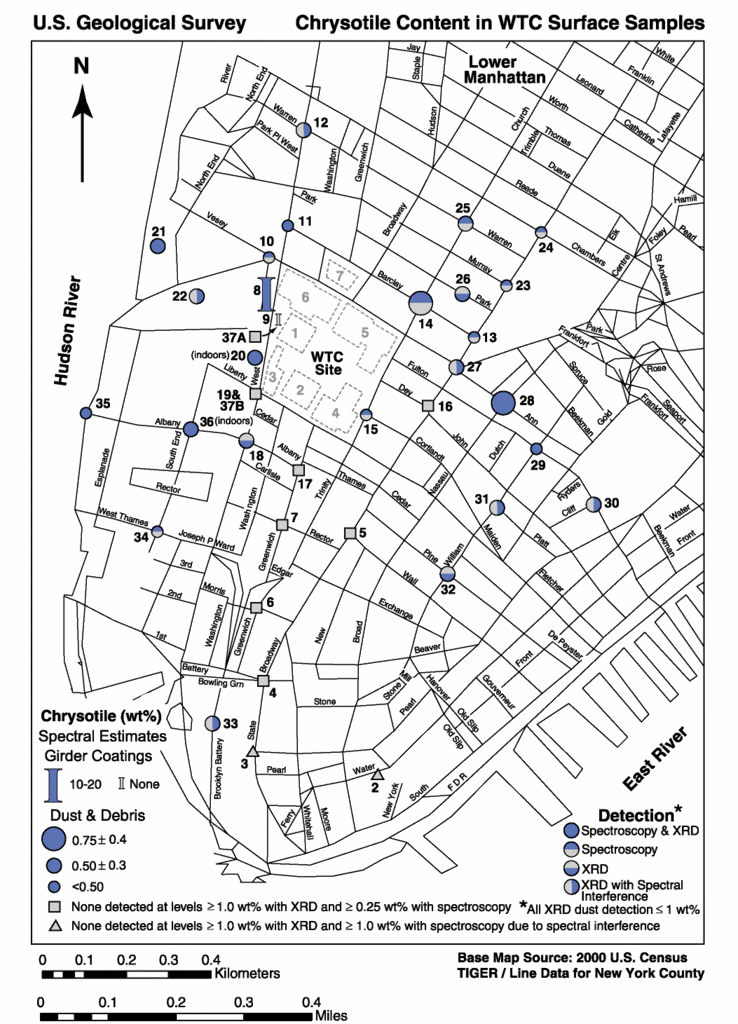
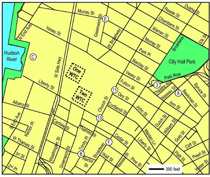
Figure 1. Map with street names
Map with street names and one-way notations.
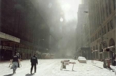
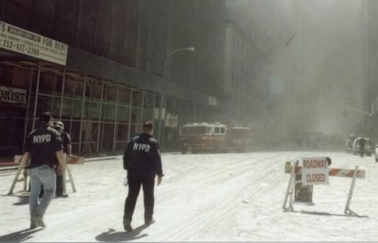
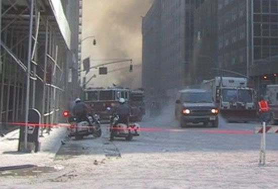
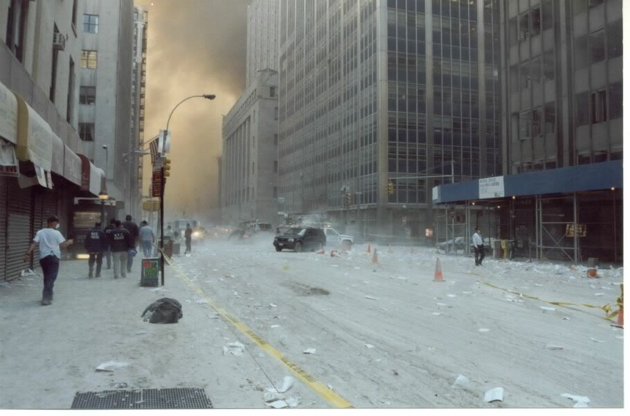
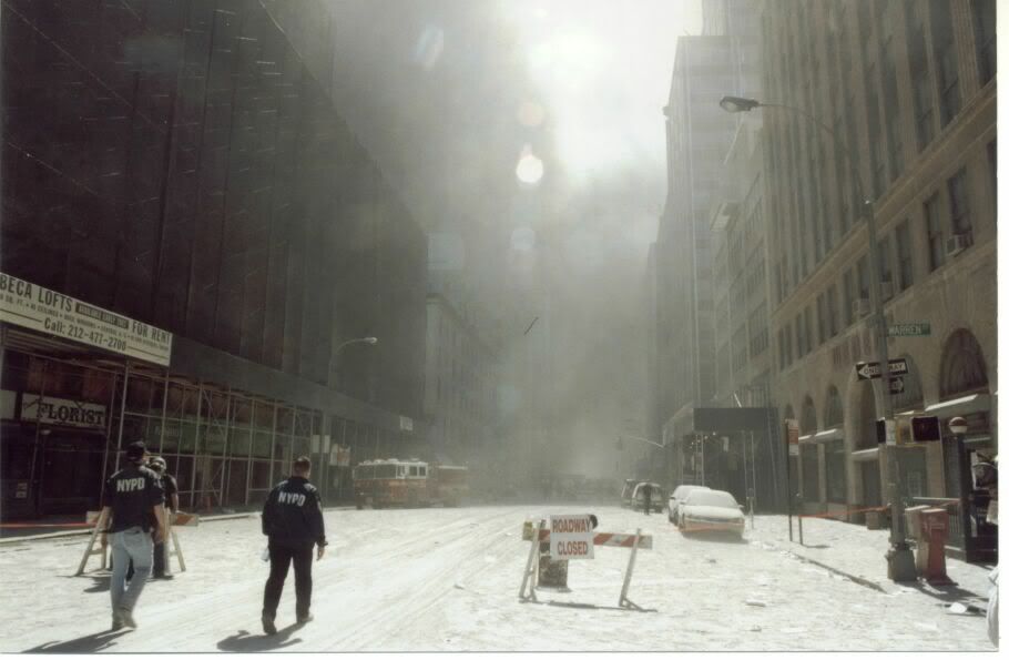
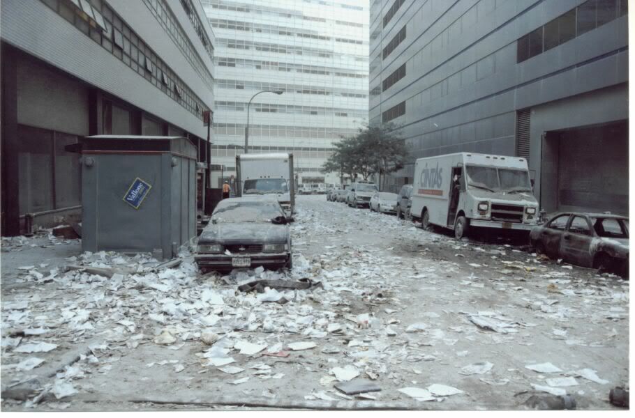
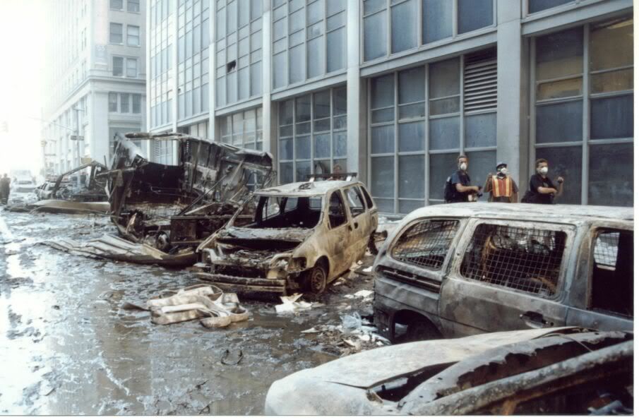
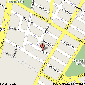
This map appears to reflect the situation after 9/11/01 as it shows Vesey Street closed off. Perhaps the one-way directions were different before 9/11/01. We need to find this out.
686 x 580 (157 kb)
360 x 360 (30 kb)
link (Source)
link (Source)
Shown at 500 x 421
Shown at full scale.360 x 360

Row 13
Raytheon
cms04_019094cs.jpg
cms04_019094cb.jpg
cms04_019094_50.jpg
cms04_019094_60.jpg
1024 x 767 (150 kb)
778 x 766 (99 kb)
1023 x 713 (74 kb)
499 x 374 (47 kb)
598 x 448 (58 kb)
shown at 267 x 200
shown at 203 x 200
shown at 286 x 200
shown at 267 x 200
shown at 267 x 200
Figure street1. The Airborne Laser (ABL) beam control system provides autonomous acquisition, pointing, and tracking capabilities.
Source: (pdf)
Figure street2.
(9/11/01) Source:
Figure street3.
(9/11/01) Source:
Figure street3.
(9/11/01) Source:
Figure street3.
(9/11/01) Source:

Row 12
cms04_019094_150.jpg
shown at 300 x 200
Figure street1.
(9/11/01) Source:

Row 11
placeholder
shown at 300 x 200
Figure street1.
(9/11/01) Source:

Row 10
placeholder
shown at 300 x 200
Figure street1.
(9/11/01) Source:

Row 9
firetruck_09.jpg
firtruck_09cs.jpg
firetruck_35.jpg
firetruck_35b.jpg
firtruck_09cbcc2.jpg
firetruck_35bbc.jpg
450 x 294 (30 kb)
550 x 354 (36 kb)
448 x 336 (42 kb)
550 x 374 (46 kb)
600 x 465 (39 kb)
437 x 466 (36 kb)
shown at 450 x 294
shown at 550 x 354
shown at 448 x 336
shown at 550 x 374
shown at 600 x 465
shown at 437 x 466
Figure firetruck1.
(9/11/01) Source:
Figure firetruck2.
(9/11/01) Source:
Figure firetruck3.
(9/11/01) Source:
Figure firetruck4.
(9/11/01) Source:
Figure firetruck5.
(9/11/01) Source:
Figure firetruck6.
(9/11/01) Source:

Row 8
locmap10.gif
chrysotilemap4.gif
wtc.gif
wtc-1.gif
wtc-2.gif
wtc-3.gif
772 x 1024 (149 kb)
738 x 1024 (161 kb)
487 x 1024 (345 kb)
487 x 1023 (114 kb)
900 x 1024 (478 kb)
900 x 1024 (124 kb)
shown at 226 x 300
shown at 216 x 200
shown at 143 x 300
shown at 143 x 300
shown at 264 x 300
shown at 264 x 300
shown at 300 x 200
shown at 300 x 200
Figure street1.
(9/11/01) Source:
Figure street2.
(9/11/01) Source:
Figure street3.
(9/11/01) Source:
Figure street4.
(9/11/01) Source:
Figure street5.
(9/11/01) Source:
Figure street6.
(9/11/01) Source:
Figure street5.
(9/11/01) Source:
Figure street5.
(9/11/01) Source:
SL Figure 1. Sample location map.
Results Figure 1. Sample location map coded by asbestos detection.
Iron Figure 1a. Ferrous, ferric iron absorption features map.
Iron Figure 2a. Ferrous, ferric iron absorption features map, without the image background so the mapped materials are easier to see.
Iron Figure 1b. Ferrous, ferric iron absorption features map, same as at right, but zoomed in to lower Manhattan.
Iron Figure 2b. Ferrous, ferric iron absorption features map, same as at right, but zoomed in to lower Manhattan.

Row 7
hybrideb hybrideb hybrideb hybrideb hybrideb hybrideb hybrideb hybrideb hybrideb hybrideb
dx3.jpg
dx2.jpg
081.jpg
080.jpg
070.jpg
069.jpg
068.jpg
031.jpg
029.jpg
010.jpg
1024 x 683 (321 kb)
1024 x 683 (321 kb)
1024 x 683 (331 kb)
1024 x 683 (331 kb)
1024 x 683 (331 kb)
1024 x 683 (293 kb)
1024 x 683 (293 kb)
1024 x 683 (265 kb)
1024 x 683 (268 kb)
1024 x 683 (306 kb)
shown at 300 x 200
shown at 300 x 200
shown at 300 x 200
shown at 300 x 200
shown at 300 x 200
shown at 300 x 200
shown at 300 x 200
shown at 300 x 200
shown at 300 x 200
shown at 300 x 200
Figure street1.
(9/1?/01) Source:
Figure street2.
(9/1?/01) Source:
Figure street3.
(9/13/01) Source:
Figure street4.
(9/13/01) Source:
Figure street5.
(9/11/01) Source:
Figure street6.
(9/11/01) Source:
Figure street6.
(9/11/01) Source:
Figure street7.
(9/1?/01) Source:
Figure street8.
(9/1?/01) Source:
Figure street9.
(9/13/01) Source:
Note the date. Quick street scrubbing!

Row 6
from study of 9/11 from study of 9/11 from study of 9/11 hybrideb Library of Congress site. Library of Congress site. Library of Congress site. individual from study of 9/11
imdf11092001213918a.jpg
imdf11092001221934a.jpg
imdf13092001014649a.jpg
024.jpg
02130v.jpg
02102v.jpg
02150v.jpg
midair_dustification.gif
Toasted_lot_wtc1.gif
333 x 450 (20 kb)
450 x 297 (18 kb)
450 x 312 (20 kb)
1024 x 683 (258 kb)
1024 x 856 (173 kb)
1024 x 731 (132 kb)
1024 x 691 (105 kb)
391 x 600 (145 kb)
665 x 416 (184 kb)
shown at 148 x 200
shown at 303 x 200
shown at 288 x 200
shown at 300 x 200
shown at 300 x 200
shown at 280 x 200
shown at 296 x 200
shown at 130 x 200
shown at 320 x 200
shown at 300 x 200
shown at 300 x 200
Figure street1.
(9/11/01) Source:
Figure street2.
(9/11/01) Source:
Figure street3.
(9/11/01) Source:
Figure street4.
(9/11/01) Source:
Figure street5.
(9/11/01) Source:
Figure street6.
(9/11/01) Source:
Figure street7.
(9/11/01) Source:
Figure street8.
(9/11/01) Source:
Figure street9.
(9/11/01) Source:
Figure street10.
(9/11/01) Source:
Figure street11.
(9/11/01) Source:
Note the boards supporting the megga cranes adjacent to the western bathtub wall. Another vehicle goes belly up.

Row 5
from study of 9/11
from study of 9/11
NYTimes
from study of 9/11 from study of 9/11 from study of 9/11 from study of 9/11 from study of 9/11
Ground_Zero_Heat_01.jpg
Ground_Zero_Heat_02.jpg
coll.jpg
Ground_Zero_Heat_03.jpg
Ground_Zero_Heat_04.jpg
Ground_Zero_Heat_05.jpg
Ground_Zero_Heat_06.jpg
Ground_Zero_Heat_07.jpg
905 x 600 (105 kb)
910 x 600 (91 kb)
315 x 450 (39 kb)
477 x 340 (16 kb)
570 x 341 (37 kb)
500 x 328 (55 kb)
565 x 465 (41 kb)
486 x 640 (34 kb)
shown at 302 x 200
shown at 303 x 200
shown at 140 x 200
shown at 281 x 200
shown at 334 x 200
shown at 305 x 200
shown at 243 x 200
shown at 152 x 200
Figure street1.
(9/11/01) Source:
Figure street2.
(9/11/01) Source:
Figure street2a.
(9/11/01) Source:
Figure street3.
(9/11/01) Source:
Figure street4.
(9/11/01) Source:
Figure street5.
(9/11/01) Source:
Figure street6.
(9/11/01) Source:
Figure street7.
(9/11/01) Source:
West Broadway, looking south toward the WTC West Broadway, looking north, away from the WTC, in front of Fiterman Hall (maybe the boxy building across from WTC7), at 30 West Broadway Under construction. Looking east on Barclay street. toasted lot toasted lot toasted lot Just south of the Liberty and West intersection, on West

Row 4
from study of 9/11 site
Ground_Zero_Streets_27.jpg
Ground_Zero_Streets_28.jpg
Ground_Zero_Streets_29.jpg
Ground_Zero_Streets_30.jpg Ground_Zero_Streets_33.jpg Ground_Zero_Streets_34.jpg Ground_Zero_Streets_35.jpg
480 x 640 (128 kb)
480 x 640 (114 kb)
640 x 480 (114 kb) 480 x 640 (86 kb) 640 x 480 (177 kb) 640 x 480 (91 kb)
640 x 480 (117 kb)
shown at 150 x 200
shown at 150 x 200
shown at 267 x 200
shown at 150 x 200
shown at 267 x 200
shown at 267 x 200
shown at 267 x 200
Figure street1.
(9/11/01) Source:
Figure street2.
(9/11/01) Source:
Figure street3.
(9/11/01) Source:
Figure street4.
(9/11/01) Source:
Figure street5.
(9/11/01) Source:
Figure street6.
(9/11/01) Source:
Figure street7.
(9/11/01) Source:

Row 3
from study of 9/11 site
Ground_Zero_Streets_14.jpg
Ground_Zero_Streets_15.jpg
Ground_Zero_Streets_16.jpg
Ground_Zero_Streets_17.jpg
Ground_Zero_Streets_18.jpg
Ground_Zero_Streets_19.jpg
Ground_Zero_Streets_25.jpg
Ground_Zero_Streets_26.jpg
905 x 600 (89 kb)
905 x 600 (73 kb)
300 x 400 (18 kb)
300 x 400 (24 kb)
300 x 400 (18 kb)
460 x 345 (19 kb)
480 x 640 (120 kb)
640 x 480 (137 kb)
shown at 302 x 200
shown at 302 x 200
shown at 150 x 200
shown at 150 x 200
shown at 150 x 200
shown at 211 x 200
shown at 150 x 200
shown at 267 x 200
Figure street1.
(9/11/01) Source:
Figure street2.
(9/11/01) Source:
Figure street3.
(9/11/01) Source:
Figure street4.
(9/11/01) Source:
Figure street5.
(9/11/01) Source:
Figure street6.
(9/11/01) Source:
Figure street7.
(9/11/01) Source:
Figure street8.
(9/11/01) Source:

Row 2
from study of 9/11 site
Ground_Zero_Streets_08.jpg
Ground_Zero_Streets_09.jpg
Ground_Zero_Streets_10.jpg
Ground_Zero_Streets_11.jpg
Ground_Zero_Streets_12.jpg
Ground_Zero_Streets_13.jpg
910 x 600 (72 kb)
910 x 595 (59 kb)
910 x 600 (92 kb)
910 x 600 (98 kb)
905 x 595 (99 kb)
905 x 595 (99 kb)
shown at 300 x 197
shown at 304 x 197
shown at 300 x 197
shown at 300 x 197
shown at 300 x 197
shown at 300 x 197
Figure street1.
(9/11/01) Source:
Figure street2.
(9/11/01) Source:
Figure street3.
(9/11/01) Source:
Figure street4.
(9/11/01) Source:
Figure street5.
(9/11/01) Source:
Figure street6.
(9/11/01) Source:
Note the toasted car on the right. It seems to be isolated. So, folks can't say that one burning car led to another...

So, how else does a car get toasted around the back side of a building? Vandalism?

Row 1
Library of Congress Site Library of Congress Site Library of Congress Site Library of Congress Site Library of Congress Site Library of Congress Site
0064v.jpg 0063v.jpg 0080v.jpg 0084v.jpg 0087v.jpg 0076v.jpg
1024 x 695 (60 kb) 1024 x 694 (50 kb) 1024 x 694 (57 kb) 1024 x 690 (72 kb)
1024 x 693 (71 kb) 1024 x 693 (96 kb)
shown at 400 x 270 shown at 400 x 270 shown at 400 x 270 shown at 401 x 270 shown at 400 x 270 shown at 399 x 270
Figure street1.
(9/11/01) Source:
Figure street2.
(9/11/01) Source:
Figure street3.
(9/11/01) Source:
Figure street4. Gone with the Wind
(9/11/01) Source:
Figure street5. Gone with the Wind
(9/11/01) Source:
Figure street6. The toasted lot burns. Curiously, it's upwind from the WTC. (9/11/01) Source:
In the above picture, you can see the next street where the bus was.
The following are from behind WTC7, looking east:
At the corner of West and Vesey, looking southeast toward the WTC complex. WTC1 just went poof and the people are emerging from their hiding places and slowly approaching the site with puzzled looks on their faces. "Where'd it go?"
This if from the library of congress. The picture is taken on Vesey street, looking west across West St. The toasted parking lot is on the right in the distance. This pic was taken after WTC1 went poof (sunlight is on WFC3, on the left). The paper in the foreground is not on fire. Why is the parking lot on fire at some distance away?